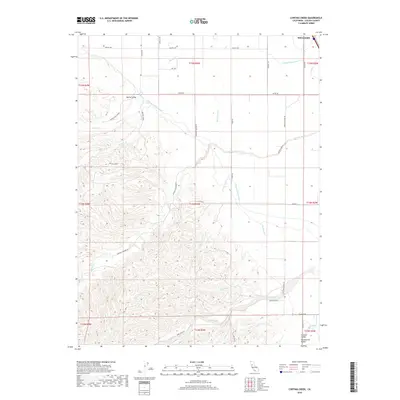
2018 Map of Cortina Creek
USGS Topo · Published 2018About this map
Williams sits at the northern edge of this landscape where the flat expanse of the Sacramento Valley meets the rising foothills of Colusa County. The terrain is defined by a sophisticated water management network, dominated by the massive Glenn-Colusa Canal and the Tehama Colusa Canal which traverse the plains to support local agriculture. Moving west, the topography shifts into the drainage basins of Cortina Creek and Walters Creek, which flow through the rolling heights of Spring Valley. This area reflects a transition between intensive valley floor farming and upland ranching, connected by a grid of named rural routes like Cortina School Rd and Cortina Vineyard Rd. Numerous seasonal drainages such as Chamisal Cr and Sand Creek carve through the southern hills, illustrating the natural watershed that feeds into the irrigation systems of the Central Valley.
Find a feature on this map
44 named features on this map. Tap any name to fly to it.
Don’t see what you’re looking for? This feature index may not catch every label — zoom into the map to look around manually.
Map Details
Editions of this 2018 Cortina Creek Map
This is the sole edition of this map. No revisions or reprints were ever made.
Other maps of this area

1905 · Harrington
USGS Topo · 1:24,000

1905 · Fairview
USGS Topo · 1:24,000

1907 · Colusa
USGS Topo · 1:62,500

1916 · Harrington
USGS Topo · 1:31,680

1918 · Williams
USGS Topo · 1:31,680

1918 · Spring Valley
USGS Topo · 1:31,680
1918 · Arbuckle
USGS Topo · 1:31,680
1918 · Powell Slough
USGS Topo · 1:31,680

1920 · Venado
USGS Topo · 1:62,500

1942 · Colusa
USGS Topo · 1:62,500