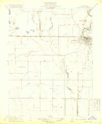
1918 Map of Powell Slough
USGS Topo · Published 1918About this map
The Sacramento River defines the eastern boundary of this 1918 survey, where the town of Colusa sits at a critical bend in the waterway. This landscape is a complex network of drainage and water management, dominated by the broad Colusa Basin and the long, winding Powell Slough. The infrastructure of early twentieth-century agriculture is clearly visible, specifically the Colusa and Lake Irrigation Company Canal and the Old Davis Levee south of town. These features reflect the transition of the Sacramento Valley into a highly engineered agricultural hub, where sloughs like Hopkins Slough were integrated into a wider system of irrigation and flood control. Local history researchers will find the grid of Colusa and the nearby Cem especially useful for tracking early land ownership and community development in the Jimeno area.
Find a feature on this map
11 named features on this map. Tap any name to fly to it.
Don’t see what you’re looking for? This feature index may not catch every label — zoom into the map to look around manually.
Map Details
Editions of this 1918 Powell Slough Map
2 editions found
Other maps of this area

1888 · Marysville
USGS Topo · 1:125,000

1891 · Marysville
USGS Topo · 1:125,000

1894 · Marysville
USGS Topo · 1:125,000

1895 · Marysville
USGS Topo · 1:125,000

1906 · Maxwell
USGS Topo · 1:62,500

1907 · Colusa
USGS Topo · 1:62,500

1911 · Sanborn Slough
USGS Topo · 1:31,680

1911 · Grimes
USGS Topo · 1:31,680

1912 · Meridian
USGS Topo · 1:31,680

1917 · Compton Landing
USGS Topo · 1:31,680