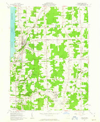
1961 Map of Cortland
USGS Topo · Published 1963About this map
Mosquito Creek Reservoir dominates the western edge of this early 1960s landscape, providing a sharp contrast to the organized agricultural and residential patterns of Cortland. The town serves as a central hub, where the Christian Ch and Lakeview High Sch sit near the reservoir’s edge. This area, part of the original Connecticut Western Reserve, is marked by numerous crossroads settlements like Kellogg Corners, Sheldon Corners, and Chadwick Corners, reflecting a traditional Midwestern township structure.
Find a feature on this map
58 named features on this map. Tap any name to fly to it.
Don’t see what you’re looking for? This feature index may not catch every label — zoom into the map to look around manually.
Map Details
Editions of this 1961 Cortland Map
3 editions found
Other maps of this area

1905 · Bristolville
USGS Topo · 1:62,500

1906 · Youngstown
USGS Topo · 1:62,500

1907 · Kinsman
USGS Topo · 1:62,500

1907 · Bristolville
USGS Topo · 1:62,500

1908 · Youngstown
USGS Topo · 1:62,500

1908 · Warren
USGS Topo · 1:62,500

1950 · Cleveland
USGS Topo · 1:250,000

1954 · Sharon West
USGS Topo · 1:24,000

1954 · Girard
USGS Topo · 1:24,000

1956 · Cleveland
USGS Topo · 1:250,000