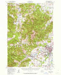
1956 Map of Corvallis
USGS Topo · Published 1962About this map
The Luckiamute River and Marys River drainages anchor this mid-century look at Benton County, where the transition from timbered foothills to the agricultural Willamette Valley is clearly visible. The expanding campus of Oregon State College dominates the western edge of Corvallis, while the neighboring town of Philomath serves as a gateway to the elevations of McDonald State Forest. To the north, the footprint of the Camp Adair Military Reservation occupies a significant portion of the landscape, including landmarks like Smith Hill and Oak Hill. Genealogy researchers will find several rural landmarks, including the Kings Valley Cem and Kings Valley Ch in the historic settlement of Kings Valley. This 1956 survey also identifies specialized structures like the Wren Guard Sta and two schoolhouses noted as abandoned, the Soap Creek Sch (Aband) and Alexander Sch (Aband), reflecting the consolidation of rural education at the time.
Find a feature on this map
76 named features on this map. Tap any name to fly to it.
Don’t see what you’re looking for? This feature index may not catch every label — zoom into the map to look around manually.
Map Details
Editions of this 1956 Corvallis Map
3 editions found
Other maps of this area

1911 · Inavale
USGS Topo · 1:31,680

1912 · Halsey
USGS Topo · 1:62,500

1913 · Philomath
USGS Topo · 1:31,680

1913 · Oakville
USGS Topo · 1:31,680

1913 · Wells
USGS Topo · 1:31,680

1914 · Independence
USGS Topo · 1:31,680

1914 · Soap Creek
USGS Topo · 1:31,680

1916 · Albany
USGS Topo · 1:62,500

1917 · Salem
USGS Topo · 1:62,500

1921 · Corvallis
USGS Topo · 1:62,500