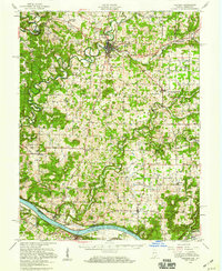
1950 Map of Corydon
USGS Topo · Published 1959About this map
Corydon serves as the focal point of this mid-century survey, situated at the confluence of Little Indian Creek and Indian Creek. The map documents a predominantly rural landscape in southern Indiana, characterized by numerous hilltop schoolhouses such as White Top Sch and Hillgrove Sch, alongside small family cemeteries like Shuck Cem and Jordan Cem. To the west, the Blue River carves a winding path through the Harrison-Crawford State Forest, while the southern border is defined by the sweeping bends of the Ohio River.
Find a feature on this map
90 named features on this map. Tap any name to fly to it.
Don’t see what you’re looking for? This feature index may not catch every label — zoom into the map to look around manually.
Map Details
Editions of this 1950 Corydon Map
This is the sole edition of this map. No revisions or reprints were ever made.
Other maps of this area

1909 · Kosmosdale
USGS Topo · 1:48,000

1912 · Kosmosdale
USGS Topo · 1:62,500

1928 · Hardinsburg
USGS Topo · 1:48,000

1931 · Hardinsburg
USGS Topo · 1:62,500

1931 · Corydon
USGS Topo · 1:62,500

1936 · Vine Grove
USGS Topo · 1:62,500

1939 · Georgetown
USGS Topo · 1:24,000

1941 · Ekron
USGS Topo · 1:62,500

1943 · Vine Grove
USGS Topo · 1:62,500

1944 · Corydon West
USGS Topo · 1:24,000