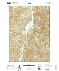
2020 Map of Cottage Grove Lake
USGS Topo · Published 2020About this map
Cottage Grove Lake dominates the center of this landscape in southern Lane County, where the Coast Fork Willamette River is impounded amidst a complex of ridges and buttes. The map documents the rural communities of London and London-Springs to the south, linked by the London Rd corridor and several river crossings including the Army Bridge and Thorne Bridge. This area is characterized by its numerous small creek drainages, such as Elkhorn Cr, Snyder Cr, and Wilson Cr, which carve through the surrounding timberlands managed via extensive road networks like the London-Weyerhaeuser Rd. For those researching local family history, the survey identifies several small burial sites including Lone Pine Cem and Taylor-Lane Cem, alongside prominent natural landmarks like Hoodoo Mtn and the Twin Prairie Buttes.
Find a feature on this map
92 named features on this map. Tap any name to fly to it.
Don’t see what you’re looking for? This feature index may not catch every label — zoom into the map to look around manually.
Map Details
Editions of this 2020 Cottage Grove Lake Map
This is the sole edition of this map. No revisions or reprints were ever made.
Other maps of this area

1921 · Cottage Grove
USGS Topo · 1:62,500

1935 · Lowell
USGS Topo · 1:96,000

1942 · Lowell
USGS Topo · 1:125,000

1954 · Anlauf
USGS Topo · 1:62,500

1955 · Culp Creek
USGS Topo · 1:62,500

1955 · Lowell
USGS Topo · 1:62,500
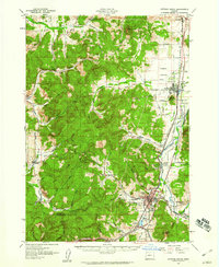
1957 · Cottage Grove
USGS Topo · 1:62,500

1958 · Roseburg
USGS Topo · 1:250,000

1959 · Roseburg
USGS Topo · 1:250,000

1979 · Cottage Grove
USGS Topo · 1:100,000