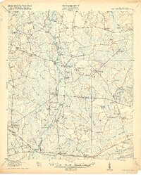
1918 Map of Cottageville
USGS Topo · Published 1918About this map
The Edisto River snakes through a landscape of expansive wetlands and historic river crossings just after the First World War. This territory, spanning the borders of Colleton, Dorchester, and Charleston counties, is defined by its reliance on water-based transport and rail. The southern edge is anchored by the Atlantic Coast Line railroad, serving settlements like Jacksonboro and Osborn. Further north, the reliance on the river is evident in the numerous landings such as Martin Landing, Padget Landing, and Beck Landing.
Find a feature on this map
86 named features on this map. Tap any name to fly to it.
Don’t see what you’re looking for? This feature index may not catch every label — zoom into the map to look around manually.
Map Details
Editions of this 1918 Cottageville Map
3 editions found
Other maps of this area

1918 · Walterboro
USGS Topo · 1:62,500

1918 · Green Pond
USGS Topo · 1:62,500

1918 · Cottageville
USGS Topo · 1:62,500

1919 · Summerville
USGS Topo · 1:48,000

1919 · Edisto Island
USGS Topo · 1:62,500

1919 · Ridgeville
USGS Topo · 1:48,000

1919 · Wadmelaw Island
USGS Topo · 1:62,500

1920 · Ravenels
USGS Topo · 1:62,500

1920 · Ridgeville
USGS Topo · 1:62,500

1920 · St. George
USGS Topo · 1:48,000