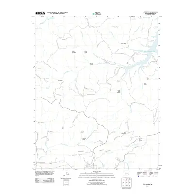
2011 Map of Cotter SW
USGS Topo · Published 2011About this map
Summit anchors the southern portion of this Marion County landscape, situated where the Ozark hills begin their descent toward the impounded waters of the White River. The 2011 topography reveals a history of extraction etched into the terrain, with numerous sites such as the Onwata Mine, Lost Bell Mine, and Lead Drift Mine concentrated in the hollows and along the ridges. These mines suggest a legacy of lead and zinc prospecting that once defined the local economy before the area transitioned toward the recreational and residential character seen near the shores of Bull Shoals Lake.
Find a feature on this map
92 named features on this map. Tap any name to fly to it.
Don’t see what you’re looking for? This feature index may not catch every label — zoom into the map to look around manually.
Map Details
Editions of this 2011 Cotter SW Map
This is the sole edition of this map. No revisions or reprints were ever made.
Other maps of this area

1893 · Yellville
USGS Topo · 1:125,000

1903 · Yellville
USGS Topo · 1:125,000

1905 · Yellville
USGS Topo · 1:125,000

1929 · Yellville
USGS Topo · 1:125,000

1945 · Harrison
USGS Topo · 1:250,000

1949 · Harrison
USGS Topo · 1:250,000

1954 · Harrison
USGS Topo · 1:250,000

1958 · Harrison
USGS Topo · 1:250,000

1964 · Harrison
USGS Topo · 1:250,000
1966 · Yellville
USGS Topo · 1:24,000