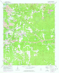
1969 Map of Cottondale
USGS Topo · Published 1978About this map
The industrial and rural landscape of Tuscaloosa County unfolds along the Black Warrior R and its tributaries in the late 1960s. This survey highlights the intense activity of the local coal industry, evidenced by numerous Strip Mines scattered north of Peterson and Fleetwood. The residential growth of Holt and Cottondale is balanced by established community landmarks, including Kennedy Chapel and Old Salem Ch.
Find a feature on this map
53 named features on this map. Tap any name to fly to it.
Don’t see what you’re looking for? This feature index may not catch every label — zoom into the map to look around manually.
Map Details
Editions of this 1969 Cottondale Map
Other maps of this area

1899 · Brookwood
USGS Topo · 1:125,000

1924 · Tuscaloosa
USGS Topo · 1:62,500

1926 · Samantha
USGS Topo · 1:48,000

1926 · Tuscaloosa
USGS Topo · 1:62,500

1928 · Samantha
USGS Topo · 1:62,500

1929 · Searles
USGS Topo · 1:48,000

1931 · Cottondale
USGS Topo · 1:48,000

1934 · Searles
USGS Topo · 1:62,500

1934 · Cottondale
USGS Topo · 1:62,500

1953 · Birmingham
USGS Topo · 1:250,000