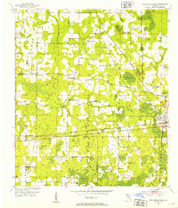
1952 Map of Cottondale West
USGS Topo · Published 1953About this map
Cottondale serves as the focal point of this 1952 topographic survey, marking the intersection of the Louisville and Nashville and the Atlanta and St Andrews Bay railroads. The landscape is a complex network of wetlands and small water bodies, notably Drummond Bay and Big Bay, interspersed with numerous named ponds like Harold Pond and Jackson Pond. This period in Jackson and Washington counties is characterized by a high density of rural social centers, indicated by the many country churches and the Lovewood Sch located near the Beacon landmark.
Find a feature on this map
32 named features on this map. Tap any name to fly to it.
Don’t see what you’re looking for? This feature index may not catch every label — zoom into the map to look around manually.
Map Details
Editions of this 1952 Cottondale West Map
2 editions found
Other maps of this area

1950 · Chipley
USGS Topo · 1:24,000

1950 · Wausau
USGS Topo · 1:24,000

1951 · Graceville
USGS Topo · 1:24,000

1951 · Chipley
USGS Topo · 1:24,000

1951 · Wausau
USGS Topo · 1:24,000

1952 · Kynesville
USGS Topo · 1:24,000

1952 · Cottondale East
USGS Topo · 1:24,000

1952 · Campbellton
USGS Topo · 1:24,000

1952 · Cottondale West
USGS Topo · 1:24,000

1952 · Sills
USGS Topo · 1:24,000