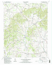
1994 Map of Cottontown
USGS Topo · Published 1997About this map
Cottontown serves as a central point in this Sumner County landscape, where the topography transitions from the winding stream valleys of Station Camp Creek to the prominent heights of Pitt Hill and Scobey Hill. The map reveals a dense network of early rural social infrastructure, notably the Sumner County Home and the Liberty Community Hall. Genealogists will find an exceptional concentration of family burial grounds, such as the Strother-Mitchell Cem, Pitt-Bursby Cem, and the Old Indian Cem, which highlight the ancestral deep-rootedness of the local community. Small-scale agricultural settlements like Johnsons Crossroads and Walnut Grove are anchored by historic meeting houses and schools, including Fairmont Sch and the Old Friendship Church. The varied terrain is defined by numerous hollows like Durham Hollow and Bandmill Hollow, reflecting a landscape where transport followed the natural drainage of Pee Dee Creek and Bug Camp Creek.
Find a feature on this map
98 named features on this map. Tap any name to fly to it.
Don’t see what you’re looking for? This feature index may not catch every label — zoom into the map to look around manually.
Map Details
Editions of this 1994 Cottontown Map
This is the sole edition of this map. No revisions or reprints were ever made.
Other maps of this area

1903 · Nashville
USGS Topo · 1:125,000

1931 · Adolphus
USGS Topo · 1:62,500

1942 · Gallatin
USGS Topo · 1:100,000

1952 · Goodlettsville
USGS Topo · 1:24,000

1952 · Hendersonville
USGS Topo · 1:24,000

1953 · Cottontown
USGS Topo · 1:24,000

1953 · Orlinda
USGS Topo · 1:24,000
1954 · White House
USGS Topo · 1:24,000

1955 · Laguardo
USGS Topo · 1:24,000

1955 · Gallatin
USGS Topo · 1:24,000