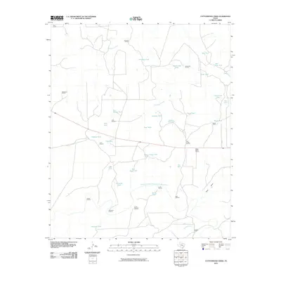
2010 Map of Cottonwood Creek
USGS Topo · Published 2010About this map
Salt Fork Brazos River and Cottonwood Creek define the arid drainage patterns of this ranchland in the early 21st century. The landscape is characterized by an extensive network of water management features essential for livestock, including numerous earthen tanks such as Hackberry Tank, Cattis Tank, and the descriptive Hole-in-Wall Tank. Established ranching operations like Bird Ranch, Beggs Ranch, and Johnson Ranch anchor the human presence in the territory, with the Beggs Ranch Airport serving as a modern transportation hub for the remote acreage. Windmills, a staple of the region's historical infrastructure, remain prominent landmarks, with names like Schoolhouse Windmill and Slicknasty Windmill suggesting the locations of earlier community focal points or topographic quirks. The map also traces the winding course of Slicknasty Creek and Home Draw, illustrating the complex hydrology of the Texas plains.
Find a feature on this map
47 named features on this map. Tap any name to fly to it.
Don’t see what you’re looking for? This feature index may not catch every label — zoom into the map to look around manually.
Map Details
Editions of this 2010 Cottonwood Creek Map
This is the sole edition of this map. No revisions or reprints were ever made.
Other maps of this area

1954 · Lubbock
USGS Topo · 1:250,000

1962 · Twomile Creek
USGS Topo · 1:24,000

1968 · Spur SW
USGS Topo · 1:24,000

1969 · Verbena
USGS Topo · 1:24,000

1969 · Cottonwood Creek
USGS Topo · 1:24,000

1969 · Justiceburg SE
USGS Topo · 1:24,000
1969 · Justiceburg NW
USGS Topo · 1:24,000

1969 · Justiceburg
USGS Topo · 1:24,000

1969 · T-O Creek
USGS Topo · 1:24,000
1969 · Polar
USGS Topo · 1:24,000