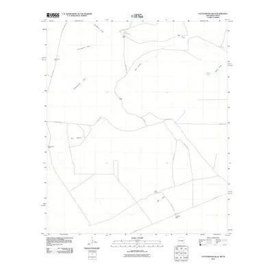
2010 Map of Cottonwood Hills
USGS Topo · Published 2010About this map
Cottonwood Ranch and Reed Ranch anchor this landscape along the Old Cavern Hwy, where the arid terrain of Eddy County is defined by a network of ephemeral watercourses. The drainage patterns of Cottonwood Draw and Hackberry Draw illustrate the vital importance of seasonal water management in this New Mexico-Texas border region. Functional landmarks such as Double Mills, Ward Waterhole, and Apple Tank highlight the infrastructure necessary for livestock and ranching in the high desert. To the south, Tecolote Peak rises above the junction of Pipeline Rd and County Rd-775, marking a transition from the Cottonwood Hills into lower draws like Owl Draw. This 2010 survey provides a clear look at the enduring ranching properties, including Boone Beach Ranch and Welch Ranch, that have shaped the local economy and land use for generations.
Find a feature on this map
21 named features on this map. Tap any name to fly to it.
Don’t see what you’re looking for? This feature index may not catch every label — zoom into the map to look around manually.
Map Details
Editions of this 2010 Cottonwood Hills Map
This is the sole edition of this map. No revisions or reprints were ever made.
Other maps of this area

1945 · Carlsbad Caverns East
USGS Topo · 1:62,500

1945 · Malaga
USGS Topo · 1:62,500

1946 · Malaga
USGS Topo · 1:62,500

1947 · Carlsbad Caverns East
USGS Topo · 1:62,500

1954 · Carlsbad
USGS Topo · 1:250,000

1954 · Van Horn
USGS Topo · 1:250,000

1958 · Van Horn
USGS Topo · 1:250,000

1958 · Carlsbad
USGS Topo · 1:250,000

1973 · Owl Hills
USGS Topo · 1:24,000
1973 · Screw Bean Draw NE
USGS Topo · 1:24,000