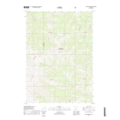
2017 Map of Cottonwood Peak
USGS Topo · Published 2017About this map
Shoshone National Forest defines this high-elevation landscape in Wyoming, where the boundary between Park and Hot Springs counties cuts through the mountain wilderness. The central prominence of Cottonwood Peak anchors a complex drainage system that feeds several watercourses, including Cottonwood Cr, Gooseberry Cr, and the N Fork Owl Cr. A network of backcountry routes, such as the Wind River Divide Trail and Chimney Creek Trail, follows the high ridges and creek beds, providing historical access through the steep terrain. Notable landmarks like the Castle Rocks formation and the high-alpine Twin Lakes further distinguish this area of the Absaroka Range, reflecting a region largely preserved in its natural state for watershed and forest management.
Find a feature on this map
20 named features on this map. Tap any name to fly to it.
Don’t see what you’re looking for? This feature index may not catch every label — zoom into the map to look around manually.
Map Details
Editions of this 2017 Cottonwood Peak Map
This is the sole edition of this map. No revisions or reprints were ever made.
Other maps of this area

1904 · Kirwin
USGS Topo · 1:125,000

1906 · Kirwin
USGS Topo · 1:125,000

1955 · Thermopolis
USGS Topo · 1:250,000

1956 · Milk Creek
USGS Topo · 1:24,000

1956 · Soapy Dale Peak
USGS Topo · 1:24,000

1958 · Thermopolis
USGS Topo · 1:250,000

1962 · Thermopolis
USGS Topo · 1:250,000
1965 · Eagle Nest Ranch
USGS Topo · 1:24,000

1967 · Willow Creek
USGS Topo · 1:24,000

1967 · Monument Peak
USGS Topo · 1:24,000