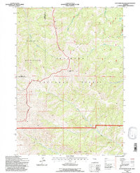
1991 Map of Cottonwood Peak
USGS Topo · Published 1997About this map
Cottonwood Peak stands as the central landmark of this high-country survey, marking a significant point on the boundary between the Shoshone National Forest and the Washakie Wilderness. This area, situated along the county line between Park County and Hot Springs County, is characterized by a complex drainage system that feeds multiple forks of the Bighorn Basin. To the north, the headwaters of Gooseberry Creek and Middle Gooseberry Creek originate near Twin Lakes, while the southern slopes descend toward the North Fork Owl Creek and South Fork Owl Creek. The presence of the Wind River Trail and the Eleventh Standard Parallel North indicates the established surveying corridors used to navigate this mountainous terrain. Prominent geological features like Castle Rocks define the lower elevations, providing clear navigational markers for those traveling through the forest interior.
Find a feature on this map
17 named features on this map. Tap any name to fly to it.
Don’t see what you’re looking for? This feature index may not catch every label — zoom into the map to look around manually.
Map Details
Editions of this 1991 Cottonwood Peak Map
This is the sole edition of this map. No revisions or reprints were ever made.
Other maps of this area

1904 · Kirwin
USGS Topo · 1:125,000

1906 · Kirwin
USGS Topo · 1:125,000

1955 · Thermopolis
USGS Topo · 1:250,000

1956 · Milk Creek
USGS Topo · 1:24,000

1956 · Soapy Dale Peak
USGS Topo · 1:24,000

1958 · Thermopolis
USGS Topo · 1:250,000

1962 · Thermopolis
USGS Topo · 1:250,000
1965 · Eagle Nest Ranch
USGS Topo · 1:24,000

1967 · Willow Creek
USGS Topo · 1:24,000

1967 · Monument Peak
USGS Topo · 1:24,000