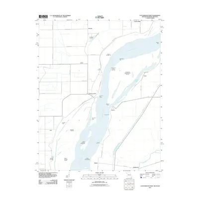
2011 Map of Cottonwood Point
USGS Topo · Published 2011About this map
The Mississippi River dominates this landscape where Missouri, Tennessee, and Arkansas converge, shaping a complex environment of bars, islands, and landings. Riverside life is centered around points of access like Cottonwood Point Landing and Heloise Landing, which historically served the small communities of Cottonwood Point and Heloise. The terrain is defined by the river's dynamic history, evidenced by the Midway Crevasse and various river-control structures such as the Cottonwood Point Dikes and Heloise Revetment. Local history is preserved in quiet landmarks like Hickman Cemetery and Taylor Cemetery, while the southern reaches of the map show the Obion River approaching its confluence near Bradleytown. The abundance of water features, from Everett Lake to the Half-Moon Lake Dam, underscores the persistent influence of the alluvial floodplains on local settlement patterns.
Find a feature on this map
50 named features on this map. Tap any name to fly to it.
Don’t see what you’re looking for? This feature index may not catch every label — zoom into the map to look around manually.
Map Details
Editions of this 2011 Cottonwood Point Map
This is the sole edition of this map. No revisions or reprints were ever made.
Other maps of this area

1939 · Hales Point
USGS Topo · 1:62,500

1939 · Caruthersville
USGS Topo · 1:62,500

1939 · Blytheville
USGS Topo · 1:62,500

1940 · Hayti
USGS Topo · 1:62,500

1951 · Caruthersville
USGS Topo · 1:62,500

1952 · Hales Point
USGS Topo · 1:62,500

1955 · Hayti
USGS Topo · 1:62,500

1955 · Blytheville
USGS Topo · 1:62,500

1956 · Dyersburg
USGS Topo · 1:250,000

1956 · Blytheville
USGS Topo · 1:250,000