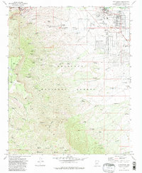
1973 Map of Cottonwood
USGS Topo · Published 1983About this map
Mingus Mountain dominates the western half of this landscape, its steep slopes marked by a dense network of mining infrastructure and deep ravines like Deception Gulch and Mescal Gulch. The legacy of the copper boom is visible in the numerous shafts and mines concentrated near Jerome, including the United Verde Mine and the Verde Central Shaft. To the east, the terrain descends into the Verde Valley where the settlement of Cottonwood serves as a regional hub. Here, the landscape transitions from the industrial mining heights to a more developed valley floor featuring the Cottonwood Airport, Mingus Union High Sch, and a Drive-in Theater near the Verde R. Numerous springs such as Baltimore Spring and Copper Chief Spring dot the mountain flanks, while complex networks of a Jeep Trail and Pack Trail provide access through the Prescott National Forest.
Find a feature on this map
82 named features on this map. Tap any name to fly to it.
Don’t see what you’re looking for? This feature index may not catch every label — zoom into the map to look around manually.
Map Details
Editions of this 1973 Cottonwood Map
3 editions found
Other maps of this area

1887 · Verde
USGS Topo · 1:250,000

1887 · Prescott
USGS Topo · 1:250,000

1892 · Verde
USGS Topo · 1:250,000

1892 · Prescott
USGS Topo · 1:250,000

1905 · Jerome
USGS Topo · 1:125,000

1923 · Camp Verde
USGS Topo · 1:125,000

1932 · Camp Verde
USGS Topo · 1:125,000

1936 · Camp Verde
USGS Topo · 1:125,000

1944 · Clarkdale
USGS Topo · 1:48,000

1944 · Mingus Mountain
USGS Topo · 1:62,500