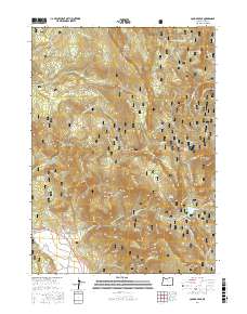
2017 Map of Cougar Peak
USGS Topo · Published 2017About this map
Fremont National Forest defines this high-elevation landscape of Lake County, where steep volcanic topography meets a network of vital natural springs. The terrain is marked by prominent summits including Cougar Peak and Angel Peak, alongside the distinctive profile of Razor Back Ridge. Drainage patterns are dictated by the descent of Drews Cr and Thomas Cr, while the distribution of water sources like Shoesole Spring and McClendon Spring suggests the historic importance of these sites for livestock and early forest management.
Find a feature on this map
39 named features on this map. Tap any name to fly to it.
Don’t see what you’re looking for? This feature index may not catch every label — zoom into the map to look around manually.
Map Details
Editions of this 2017 Cougar Peak Map
This is the sole edition of this map. No revisions or reprints were ever made.
Other maps of this area

1955 · Klamath Falls
USGS Topo · 1:250,000

1958 · Klamath Falls
USGS Topo · 1:250,000

1960 · Strawberry Butte
USGS Topo · 1:62,500

1960 · Fishhole Mtn
USGS Topo · 1:62,500

1964 · Drews Reservoir
USGS Topo · 1:24,000

1964 · Cox Flat
USGS Topo · 1:24,000

1964 · Coleman Point
USGS Topo · 1:24,000

1964 · Cougar Peak
USGS Topo · 1:24,000

1964 · Shoestring Butte
USGS Topo · 1:24,000

1964 · Drews Gap
USGS Topo · 1:24,000