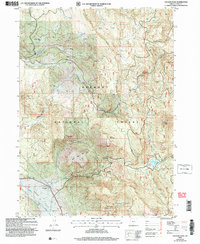
2004 Map of Cougar Peak
USGS Topo · Published 2007About this map
Fremont National Forest dominates this section of southern Oregon, characterized by a complex network of high ridges and secluded flats. The landscape transitions from the expansive Drews Valley Creek drainage to the prominent heights of Cougar Peak and Grizzly Peak in the east. Local history is etched into the terrain through family and descriptive names like the Drews Valley Ranch and distinctive landmarks such as Dutch Oven Flat, Shoesole Flat, and Razor Back Ridge.
Find a feature on this map
31 named features on this map. Tap any name to fly to it.
Don’t see what you’re looking for? This feature index may not catch every label — zoom into the map to look around manually.
Map Details
Editions of this 2004 Cougar Peak Map
This is the sole edition of this map. No revisions or reprints were ever made.
Other maps of this area

1955 · Klamath Falls
USGS Topo · 1:250,000

1958 · Klamath Falls
USGS Topo · 1:250,000

1960 · Strawberry Butte
USGS Topo · 1:62,500

1960 · Fishhole Mtn
USGS Topo · 1:62,500

1964 · Drews Reservoir
USGS Topo · 1:24,000

1964 · Cox Flat
USGS Topo · 1:24,000

1964 · Coleman Point
USGS Topo · 1:24,000

1964 · Cougar Peak
USGS Topo · 1:24,000

1964 · Shoestring Butte
USGS Topo · 1:24,000

1964 · Drews Gap
USGS Topo · 1:24,000