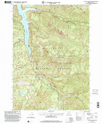
1997 Map of Cougar Reservoir
USGS Topo · Published 2001About this map
Cougar Reservoir serves as the central focal point of this late 20th-century landscape, nestled within the expansive boundaries of the Willamette National Forest. The map details the confluence of the South Fork Mc Kenzie River and its numerous tributaries, including Basalt Creek and Annie Creek, as they feed into the reservoir's deep waters. Along the western shoreline, visitors and researchers can identify recreational landmarks like the Slide Creek Campground and Day Use Area and the thermal waters of Terwilliger Hot Spring.
Find a feature on this map
50 named features on this map. Tap any name to fly to it.
Don’t see what you’re looking for? This feature index may not catch every label — zoom into the map to look around manually.
Map Details
Editions of this 1997 Cougar Reservoir Map
This is the sole edition of this map. No revisions or reprints were ever made.
Other maps of this area

1925 · Waldo Lake
USGS Topo · 1:125,000

1934 · Mc Kenzie Bridge
USGS Topo · 1:96,000

1940 · Mc Kenzie Bridge
USGS Topo · 1:125,000

1953 · Salem
USGS Topo · 1:250,000

1954 · Salem
USGS Topo · 1:250,000

1955 · Chucksney Mtn
USGS Topo · 1:62,500

1955 · Blue River
USGS Topo · 1:62,500

1955 · Mc Kenzie Bridge
USGS Topo · 1:62,500

1956 · Sardine Butte
USGS Topo · 1:62,500

1958 · Roseburg
USGS Topo · 1:250,000