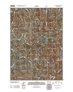
2011 Map of Cougar Rock
USGS Topo · Published 2011About this map
Cougar Rock and Eagle Rock serve as central landmarks in this portion of Grant County, where the landscape is defined by an intricate network of drainages and high meadows. The area around Four Corners acts as a junction for local travel, connecting various forest routes such as E Beech Creek Rd and Keeney Forks Rd. This 2011 survey by the U.S. Geological Survey illustrates a region dominated by water systems, with Camp Creek winding through the center and Grub Creek and Hall Creek carving through the southern terrain. Evidence of seasonal grazing and natural water sources are present at Coxie Meadow and Voight Spring, while the northern reaches are marked by the prominent Twin Buttes. The map reveals a place of active forest management and water resource geography, where numerous smaller tributaries like Steep Creek and Charlie Creek feed into larger systems.
Find a feature on this map
23 named features on this map. Tap any name to fly to it.
Don’t see what you’re looking for? This feature index may not catch every label — zoom into the map to look around manually.
Map Details
Editions of this 2011 Cougar Rock Map
This is the sole edition of this map. No revisions or reprints were ever made.
Other maps of this area

1940 · John Day
USGS Topo · 1:62,500

1943 · John Day
USGS Topo · 1:62,500

1949 · Susanville
USGS Topo · 1:62,500

1951 · Susanville
USGS Topo · 1:62,500

1951 · Bates
USGS Topo · 1:62,500

1955 · Canyon City
USGS Topo · 1:250,000

1959 · Canyon City
USGS Topo · 1:250,000

1959 · Prairie City
USGS Topo · 1:62,500

1972 · John Day
USGS Topo · 1:24,000
1972 · Castle Creek
USGS Topo · 1:24,000