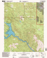
2001 Map of Coulterville
USGS Topo · Published 2004About this map
Coulterville serves as the historic focal point of this Mother Lode region at the turn of the 21st century, situated near the boundary of Tuolumne and Mariposa counties. The landscape is deeply marked by its mining heritage, with numerous Prospects and named operations like the Mary Harrison Mine and Gold Coin Mine scattered across the hills. To the west, the massive expanse of Lake McClure fills the canyon, including the distinct Horseshoe Bend and the Picture Gallery shoreline.
Find a feature on this map
47 named features on this map. Tap any name to fly to it.
Don’t see what you’re looking for? This feature index may not catch every label — zoom into the map to look around manually.
Map Details
Editions of this 2001 Coulterville Map
2 editions found
Other maps of this area

1893 · Sonora
USGS Topo · 1:125,000

1896 · Sonora
USGS Topo · 1:125,000

1897 · Sonora
USGS Topo · 1:125,000

1898 · Sonora
USGS Topo · 1:125,000

1916 · Merced Falls
USGS Topo · 1:24,000

1919 · Merced Falls
USGS Topo · 1:31,680

1944 · Merced Falls
USGS Topo · 1:62,500

1947 · San Jose
USGS Topo · 1:250,000

1947 · Coulterville
USGS Topo · 1:62,500
1947 · Jawbone Ridge
USGS Topo · 1:24,000