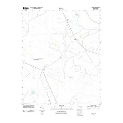
2010 Map of Council
USGS Topo · Published 2010About this map
The Cape Fear River and its intricate drainage network define this pocket of North Carolina, where agriculture and low-lying wetlands meet. The settlement of Council sits at a geographic crossroads, surrounded by water management features such as the Council Mill Pond Dam and Meares Millpond. These millponds and branches, including Boggy Branch and Sasspan Branch, suggest a long history of utilizing the local hydrology for regional industry and community development.
Find a feature on this map
46 named features on this map. Tap any name to fly to it.
Don’t see what you’re looking for? This feature index may not catch every label — zoom into the map to look around manually.
Map Details
Editions of this 2010 Council Map
This is the sole edition of this map. No revisions or reprints were ever made.
Other maps of this area

1953 · Florence
USGS Topo · 1:250,000

1954 · Florence
USGS Topo · 1:250,000

1954 · White Lake
USGS Topo · 1:62,500

1954 · Bolton
USGS Topo · 1:62,500

1955 · Whiteville
USGS Topo · 1:62,500

1955 · Elizabethtown
USGS Topo · 1:62,500

1982 · Elizabethtown
USGS Topo · 1:100,000
1986 · Lake Waccamaw East
USGS Topo · 1:24,000
1986 · Freeman
USGS Topo · 1:24,000
1986 · Singletary Lake
USGS Topo · 1:24,000