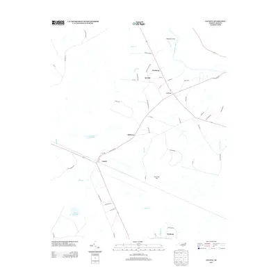
2013 Map of Council
USGS Topo · Published 2013About this map
Council and its surrounding coastal plain landscape appear here in a recent topographical study, defined by the slow-moving waters of the Cape Fear River and its numerous tributaries. The map details a community centered on agricultural and timber lands, punctuated by significant water bodies like Council Millpond and Meares Millpond. Distinctive terrain features such as Seven Mile Bay and Deepwater Point illustrate the low-lying, often swampy nature of the Bladen County interior. Smaller named settlements including Westbrook, Baltimore, and Buckhead are connected by a network of rural roads such as S Elwell Ferry Rd, hinting at the historic importance of river crossings and local mills in this region. The landscape is heavily crisscrossed by drainage branches like Boggy Br and Kitchens Br, which flow through the timbered pocosin and bay environments that characterize the area's geography.
Find a feature on this map
55 named features on this map. Tap any name to fly to it.
Don’t see what you’re looking for? This feature index may not catch every label — zoom into the map to look around manually.
Map Details
Editions of this 2013 Council Map
This is the sole edition of this map. No revisions or reprints were ever made.
Other maps of this area

1953 · Florence
USGS Topo · 1:250,000

1954 · Florence
USGS Topo · 1:250,000

1954 · White Lake
USGS Topo · 1:62,500

1954 · Bolton
USGS Topo · 1:62,500

1955 · Whiteville
USGS Topo · 1:62,500

1955 · Elizabethtown
USGS Topo · 1:62,500

1982 · Elizabethtown
USGS Topo · 1:100,000
1986 · Lake Waccamaw East
USGS Topo · 1:24,000
1986 · Freeman
USGS Topo · 1:24,000
1986 · Singletary Lake
USGS Topo · 1:24,000