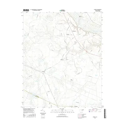
2016 Map of Council
USGS Topo · Published 2016About this map
The Cape Fear River dominates the northeastern landscape of this Bladen County region, where the historical settlement patterns are tied to the river and its swampy lowlands. The small communities of Westbrook, Carvers, and Red Hill cluster near the river's path, while Council sits further south along the county line. This area is characterized by an extensive network of Carolina bays, including the large Seven Mile Bay and Sasspan Bay, which influence the local drainage patterns. These unique elliptical depressions, along with water bodies like Council Millpond and Dodds Millpond, illustrate the hydrological complexity of the coastal plain. For researchers, the presence of family-named landmarks such as Braddy Plantation Rd and the McEwen Cem near Buckhead provides valuable genealogical clues to the families who cultivated and settled this land in earlier generations.
Find a feature on this map
63 named features on this map. Tap any name to fly to it.
Don’t see what you’re looking for? This feature index may not catch every label — zoom into the map to look around manually.
Map Details
Editions of this 2016 Council Map
This is the sole edition of this map. No revisions or reprints were ever made.
Other maps of this area

1953 · Florence
USGS Topo · 1:250,000

1954 · Florence
USGS Topo · 1:250,000

1954 · White Lake
USGS Topo · 1:62,500

1954 · Bolton
USGS Topo · 1:62,500

1955 · Whiteville
USGS Topo · 1:62,500

1955 · Elizabethtown
USGS Topo · 1:62,500

1982 · Elizabethtown
USGS Topo · 1:100,000
1986 · Lake Waccamaw East
USGS Topo · 1:24,000
1986 · Freeman
USGS Topo · 1:24,000
1986 · Singletary Lake
USGS Topo · 1:24,000