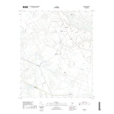
2019 Map of Council
USGS Topo · Published 2019About this map
The Cape Fear River winds across the northeastern portion of this coastal plain landscape, defining a region where numerous pocosin-like "bays" dot the terrain. These elliptical depressions, such as Seven Mile Bay, Sasspan Bay, and Wolf Bay, are characteristic of the Carolina backcountry and dictate the placement of roads and small settlements. The area is divided by the Bladen Co Columbus Co line, with the primary hub at Council positioned near the Council Millpond.
Find a feature on this map
59 named features on this map. Tap any name to fly to it.
Don’t see what you’re looking for? This feature index may not catch every label — zoom into the map to look around manually.
Map Details
Editions of this 2019 Council Map
This is the sole edition of this map. No revisions or reprints were ever made.
Other maps of this area

1953 · Florence
USGS Topo · 1:250,000

1954 · Florence
USGS Topo · 1:250,000

1954 · White Lake
USGS Topo · 1:62,500

1954 · Bolton
USGS Topo · 1:62,500

1955 · Whiteville
USGS Topo · 1:62,500

1955 · Elizabethtown
USGS Topo · 1:62,500

1982 · Elizabethtown
USGS Topo · 1:100,000
1986 · Lake Waccamaw East
USGS Topo · 1:24,000
1986 · Freeman
USGS Topo · 1:24,000
1986 · Singletary Lake
USGS Topo · 1:24,000