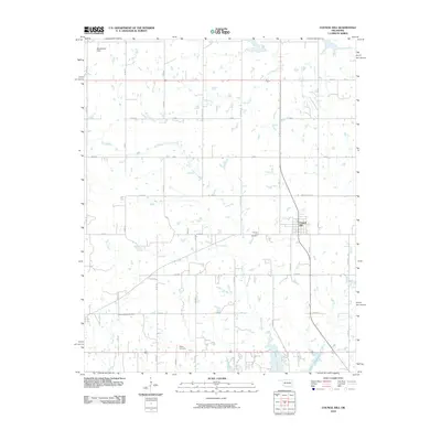
2010 Map of Council Hill
USGS Topo · Published 2010About this map
Council Hill serves as the primary settlement center on this Oklahoma landscape, surrounded by a grid of rural section roads and multiple watercourses. The town's historic footprint is anchored by the Council Hill Cemetery to its west, while the northern reaches of Lake Eufaula define the southern boundary of the quadrangle. This area of Muskogee County is characterized by its agricultural layout, where family and local heritage are preserved in smaller burial sites such as the Hitchita-Lackey Cemetery and Ridley Cemetery. Numerous drainage systems including Gentry Creek, Cloud Creek, and Putty Creek weave through the terrain, suggesting a landscape defined by its creek valleys. In the northwest corner, Meadowlark Field provides a distinct landmark amidst the sprawling network of numbered rural roads that facilitate movement across the prairie.
Find a feature on this map
35 named features on this map. Tap any name to fly to it.
Don’t see what you’re looking for? This feature index may not catch every label — zoom into the map to look around manually.
Map Details
Editions of this 2010 Council Hill Map
This is the sole edition of this map. No revisions or reprints were ever made.
Other maps of this area

1896 · Okmulgee
USGS Topo · 1:125,000

1900 · Canadian
USGS Topo · 1:125,000

1900 · Okmulgee
USGS Topo · 1:125,000

1946 · Fort Smith
USGS Topo · 1:250,000

1962 · Pierce
USGS Topo · 1:24,000

1962 · Hoffman
USGS Topo · 1:24,000

1963 · Checotah
USGS Topo · 1:24,000

1965 · Fort Smith
USGS Topo · 1:250,000

1967 · Fort Smith
USGS Topo · 1:250,000
1970 · Wainwright
USGS Topo · 1:24,000