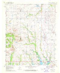
1970 Map of Council Hill
USGS Topo · Published 1972About this map
Council Hill and Hitchita anchor this landscape at the intersection of Muskogee, Okmulgee, and McIntosh counties during the early 1970s. The southern reach of the map is defined by the rising waters of the Eufaula Reservoir, where the Gentry Creek Public Use Area meets the shoreline. The terrain is marked by industrial activity, with numerous oil wells and a gas well scattered across the northern sections, particularly near the St Louis and San Francisco railroad line. Topographically, High Spring Mountain rises as a prominent landmark in the southwest, while local social history is preserved through several rural institutions like Lone Tree Ch, New Hope Ch, and the Hitchita-Lackey Cem. The map provides a detailed view of the regional infrastructure, from the Texas and Pacific rail corridor to the private Foster Landing Strip.
Find a feature on this map
30 named features on this map. Tap any name to fly to it.
Don’t see what you’re looking for? This feature index may not catch every label — zoom into the map to look around manually.
Map Details
Editions of this 1970 Council Hill Map
2 editions found
Other maps of this area

1896 · Okmulgee
USGS Topo · 1:125,000

1900 · Canadian
USGS Topo · 1:125,000

1900 · Okmulgee
USGS Topo · 1:125,000

1946 · Fort Smith
USGS Topo · 1:250,000

1962 · Pierce
USGS Topo · 1:24,000

1962 · Hoffman
USGS Topo · 1:24,000

1963 · Checotah
USGS Topo · 1:24,000

1965 · Fort Smith
USGS Topo · 1:250,000

1967 · Fort Smith
USGS Topo · 1:250,000
1970 · Wainwright
USGS Topo · 1:24,000