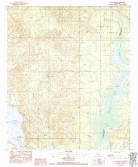
1983 Map of Coup Point
USGS Topo · Published 1984About this map
Black Lake Oil and Gas Field dominates the central landscape of this Natchitoches Parish region, reflecting the intensive energy extraction that shaped local geography in the early 1980s. The map illustrates a complex network of industrial infrastructure, including the Gas Processing Plant and various oil columns, intertwined with the natural water systems of Saline Lake and Black Lake. To the north and east, the protected lands of the Kisatchie National Forest provide a sharp contrast to the industrial zones, maintaining a wilderness character along Big Fordoche Creek.
Find a feature on this map
30 named features on this map. Tap any name to fly to it.
Don’t see what you’re looking for? This feature index may not catch every label — zoom into the map to look around manually.
Map Details
Editions of this 1983 Coup Point Map
This is the sole edition of this map. No revisions or reprints were ever made.
Other maps of this area

1937 · Campti NE
USGS Topo · 1:31,680

1937 · Campti SE
USGS Topo · 1:31,680

1944 · Campti
USGS Topo · 1:62,500

1947 · Goldonna
USGS Topo · 1:62,500

1947 · Ashland
USGS Topo · 1:62,500

1948 · Campti
USGS Topo · 1:62,500

1949 · Calvin SE
USGS Topo · 1:31,680

1949 · Calvin NE
USGS Topo · 1:31,680

1949 · Calvin NW
USGS Topo · 1:31,680

1949 · Calvin SW
USGS Topo · 1:31,680