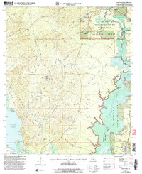
2003 Map of Coup Point
USGS Topo · Published 2005About this map
Kisatchie National Forest dominates this landscape along the border of Natchitoches and Winn parishes, where the Saline Bayou is preserved as a National Wild and Scenic River. The map reveals a complex water system where Saline Lake, Black Lake, and Clear Lake meet, creating a maze of inlets and points such as Burnt Pine Point and Coup Point. This area reflects a transition from protected wilderness to active natural resource extraction, evidenced by the extensive Oil and Gas Field and numerous pipelines that crisscross the terrain.
Find a feature on this map
37 named features on this map. Tap any name to fly to it.
Don’t see what you’re looking for? This feature index may not catch every label — zoom into the map to look around manually.
Map Details
Editions of this 2003 Coup Point Map
This is the sole edition of this map. No revisions or reprints were ever made.
Other maps of this area

1937 · Campti NE
USGS Topo · 1:31,680

1937 · Campti SE
USGS Topo · 1:31,680

1944 · Campti
USGS Topo · 1:62,500

1947 · Goldonna
USGS Topo · 1:62,500

1947 · Ashland
USGS Topo · 1:62,500

1948 · Campti
USGS Topo · 1:62,500

1949 · Calvin SE
USGS Topo · 1:31,680

1949 · Calvin NE
USGS Topo · 1:31,680

1949 · Calvin NW
USGS Topo · 1:31,680

1949 · Calvin SW
USGS Topo · 1:31,680