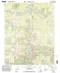
1999 Map of Courtois
USGS Topo · Published 2002About this map
Courtois Creek and its many tributaries, including Hazel Creek, flow through this section of the Mark Twain National Forest along the border of Crawford and Washington Counties. The landscape is defined by deep hollows such as Todd Hollow and Boiling Springs Hollow, which supported small, dispersed communities during the late 20th century. Local religious and social life is anchored by landmarks like Sugar Grove Ch, Bethel Ch, and Joseph Chapel.
Find a feature on this map
37 named features on this map. Tap any name to fly to it.
Don’t see what you’re looking for? This feature index may not catch every label — zoom into the map to look around manually.
Map Details
Editions of this 1999 Courtois Map
This is the sole edition of this map. No revisions or reprints were ever made.
Other maps of this area

1906 · Potosi
USGS Topo · 1:62,500

1924 · Edgehill
USGS Topo · 1:62,500

1926 · Edgehill
USGS Topo · 1:62,500

1943 · Berryman
USGS Topo · 1:62,500

1943 · Boss
USGS Topo · 1:62,500

1945 · Berryman
USGS Topo · 1:62,500

1946 · Boss
USGS Topo · 1:62,500

1949 · Rolla
USGS Topo · 1:250,000

1953 · Rolla
USGS Topo · 1:250,000

1954 · Rolla
USGS Topo · 1:250,000