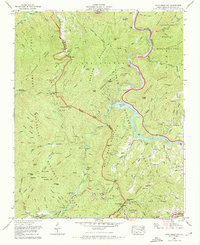
1967 Map of Cove Creek Gap
USGS Topo · Published 1971About this map
Great Smoky Mountains National Park and the Pisgah National Forest converge here along the Pigeon River. This 1960s landscape is defined by the sharp transition between protected wilderness and the engineering of Walters Lake, created by the Walters Dam. Evidence of early mountain life remains at high elevations, with small settlements like Ola and Cataloochee situated along the winding paths of the Asbury Trail. Local genealogy is deeply etched into the terrain, marked by family burial grounds such as Sutton Cem, Herrell Cem, and Hannah Cem. Near the confluence of Cataloochee Creek and Caldwell Fork, a Ranger Station and Palmer Chapel anchor the valley floor, while further east, an abandoned mine and the White Oak Community Center reflect the area's shifting industrial and social focus.
Find a feature on this map
116 named features on this map. Tap any name to fly to it.
Don’t see what you’re looking for? This feature index may not catch every label — zoom into the map to look around manually.
Map Details
Editions of this 1967 Cove Creek Gap Map
4 editions found
Other maps of this area

1893 · Mt Guyot
USGS Topo · 1:125,000

1894 · Asheville
USGS Topo · 1:125,000

1901 · Asheville
USGS Topo · 1:125,000

1912 · Mt Guyot
USGS Topo · 1:125,000

1935 · Newport
USGS Topo · 1:48,000

1935 · Hartford
USGS Topo · 1:24,000

1935 · Dellwood
USGS Topo · 1:24,000

1935 · Clyde
USGS Topo · 1:24,000

1935 · Lemon Gap
USGS Topo · 1:24,000

1936 · Bunches Bald
USGS Topo · 1:24,000