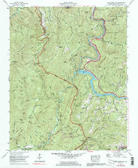
1967 Map of Cove Creek Gap
USGS Topo · Published 1991About this map
The Great Smoky Mountains National Park dominates this landscape, showing the protected wilderness of the Great Smoky Mountains during the late 1960s. The map highlights the high ridges of the Bunk Mountains and Sterling Ridge, while documenting the deep cultural roots of the area through family-named landmarks and cemeteries. Sites like Palmer Chapel and the Little Cataloochee Ch provide clear evidence of the community that once thrived in the narrow mountain valleys before the land became park territory.
Find a feature on this map
120 named features on this map. Tap any name to fly to it.
Don’t see what you’re looking for? This feature index may not catch every label — zoom into the map to look around manually.
Map Details
Editions of this 1967 Cove Creek Gap Map
4 editions found
Other maps of this area

1893 · Mt Guyot
USGS Topo · 1:125,000

1894 · Asheville
USGS Topo · 1:125,000

1901 · Asheville
USGS Topo · 1:125,000

1912 · Mt Guyot
USGS Topo · 1:125,000

1935 · Newport
USGS Topo · 1:48,000

1935 · Hartford
USGS Topo · 1:24,000

1935 · Dellwood
USGS Topo · 1:24,000

1935 · Clyde
USGS Topo · 1:24,000

1935 · Lemon Gap
USGS Topo · 1:24,000

1936 · Bunches Bald
USGS Topo · 1:24,000