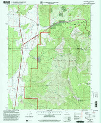
2001 Map of Cove Fort
USGS Topo · Published 2003About this map
Old Cove Fort stands as the historical anchor of this landscape, situated near the intersection of modern transport corridors and ancient mountain trails. This 2001 revision illustrates a complex intersection of land uses, from the preserved stone fortification at Cove Fort to the industrial activity at Sulphurdale. The terrain rises sharply from the Alkali Flat into the high elevations of the Tushar Mountains, much of which is managed as part of the Fish Lake National Forest. Evidence of natural resource extraction and exploration is visible throughout the slopes, marked by numerous Prospects, a Geothermal Well, and several Pits. These features, alongside family-named landmarks and water sources like Dead Cow Spring and Shingle Creek Meadows, trace the long history of human effort to harness the water and minerals of this arid high-altitude environment.
Find a feature on this map
42 named features on this map. Tap any name to fly to it.
Don’t see what you’re looking for? This feature index may not catch every label — zoom into the map to look around manually.
Map Details
Editions of this 2001 Cove Fort Map
This is the sole edition of this map. No revisions or reprints were ever made.
Other maps of this area

1885 · Beaver
USGS Topo · 1:250,000

1932 · Sevier
USGS Topo · 1:62,500

1935 · Sevier
USGS Topo · 1:62,500

1937 · Delano Peak
USGS Topo · 1:48,000

1943 · Delano Peak
USGS Topo · 1:62,500

1953 · Richfield
USGS Topo · 1:250,000

1954 · Beaver NE
USGS Topo · 1:24,000

1958 · Richfield
USGS Topo · 1:250,000

1958 · Beaver
USGS Topo · 1:62,500

1962 · Cove Fort
USGS Topo · 1:62,500