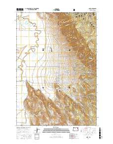
2017 Map of Cove
USGS Topo · Published 2017About this map
Cove sits at the foot of the mountains where the Grande Ronde Valley meets the eastern slopes of the Whitman National Forest. This 2017 survey details a landscape defined by its water resources and agricultural infrastructure, from the Elmers Reservoir system in the northwest to the complex irrigation network of Catherine Cr Highline Canal and Phys Slough in the southwest. The town's geothermal character is anchored by Cove Hot Springs, while its civic history is represented by the centrally located Cove Cem.
Find a feature on this map
63 named features on this map. Tap any name to fly to it.
Don’t see what you’re looking for? This feature index may not catch every label — zoom into the map to look around manually.
Map Details
Editions of this 2017 Cove Map
This is the sole edition of this map. No revisions or reprints were ever made.
Other maps of this area

1906 · Telocaset
USGS Topo · 1:125,000

1955 · Grangeville
USGS Topo · 1:250,000

1959 · Grangeville
USGS Topo · 1:250,000

1965 · Conley
USGS Topo · 1:24,000

1965 · Union
USGS Topo · 1:24,000

1965 · Cove
USGS Topo · 1:24,000
1965 · Gasset Bluff
USGS Topo · 1:24,000
1965 · Imbler
USGS Topo · 1:24,000
1965 · Mount Moriah
USGS Topo · 1:24,000

1965 · Little Catherine Creek
USGS Topo · 1:24,000