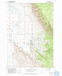
1993 Map of Cove
USGS Topo · Published 1993About this map
Agricultural life in the Grande Ronde Valley is meticulously detailed here, centered on the community of Cove at the foot of the Whitman National Forest. The map illustrates the transition from the flat, irrigated valley floor to the steep eastern timberlands. Local infrastructure is well-defined, showing a network of rural lanes like Lantz Lane and Duncan Lane that connect outlying homesteads and the small settlements of Eckesley and Shanghai. Educational and social hubs of the late 20th century are marked by the High Sch and the Grange Hall.
Find a feature on this map
33 named features on this map. Tap any name to fly to it.
Don’t see what you’re looking for? This feature index may not catch every label — zoom into the map to look around manually.
Map Details
Editions of this 1993 Cove Map
This is the sole edition of this map. No revisions or reprints were ever made.
Other maps of this area

1906 · Telocaset
USGS Topo · 1:125,000

1955 · Grangeville
USGS Topo · 1:250,000

1959 · Grangeville
USGS Topo · 1:250,000

1965 · Conley
USGS Topo · 1:24,000

1965 · Union
USGS Topo · 1:24,000

1965 · Cove
USGS Topo · 1:24,000
1965 · Gasset Bluff
USGS Topo · 1:24,000
1965 · Imbler
USGS Topo · 1:24,000
1965 · Mount Moriah
USGS Topo · 1:24,000

1965 · Little Catherine Creek
USGS Topo · 1:24,000