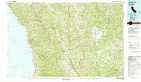
1981 Map of Covelo
USGS Topo · Published 1981About this map
Round Valley serves as a distinct agricultural and cultural hub on this Mendocino County landscape, centered on the town of Covelo. The map reveals a complex arrangement of land use and jurisdictional boundaries, including the Round Valley Indian Reservation Boundary, the Laytonville Indian Reservation, and the Sherwood Valley Rancheria. These designations exist alongside the expansive Mendocino National Forest, illustrating the varied historical tenure of the region.
Find a feature on this map
99 named features on this map. Tap any name to fly to it.
Don’t see what you’re looking for? This feature index may not catch every label — zoom into the map to look around manually.
Map Details
Editions of this 1981 Covelo Map
2 editions found
Other maps of this area

1890 · Red Bluff
USGS Topo · 1:250,000

1894 · Red Bluff
USGS Topo · 1:250,000

1920 · Glenblair
USGS Topo · 1:62,500

1920 · Pt. Delagda
USGS Topo · 1:62,500

1920 · Cummings
USGS Topo · 1:62,500

1920 · Covelo
USGS Topo · 1:62,500

1920 · Harris
USGS Topo · 1:62,500

1920 · Fort Bragg
USGS Topo · 1:62,500

1921 · Westport
USGS Topo · 1:62,500

1921 · Briceland
USGS Topo · 1:62,500