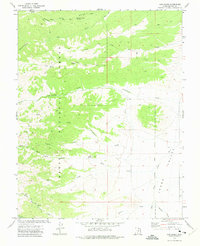
1971 Map of Cow Creek
USGS Topo · Published 1975About this map
Dixie National Forest dominates this section of southern Utah, where a network of primitive transportation routes defines the high-altitude landscape. The map reveals the intricate drainage systems of the eastern plateaus, with Cottonwood Creek, Deer Creek, and Rock Creek carving through the terrain before reaching the broader expanse of Johns Valley. The presence of the East Fork Sevier River in the southeast corner signifies the primary water source for the region's agricultural and ranching efforts.
Find a feature on this map
23 named features on this map. Tap any name to fly to it.
Don’t see what you’re looking for? This feature index may not catch every label — zoom into the map to look around manually.
Map Details
Editions of this 1971 Cow Creek Map
This is the sole edition of this map. No revisions or reprints were ever made.
Other maps of this area

1885 · Beaver
USGS Topo · 1:250,000

1885 · Fish Lake
USGS Topo · 1:250,000

1886 · Kanab
USGS Topo · 1:250,000

1886 · Escalante
USGS Topo · 1:250,000

1896 · Fish Lake
USGS Topo · 1:250,000

1953 · Richfield
USGS Topo · 1:250,000

1953 · Cedar City
USGS Topo · 1:250,000

1956 · Escalante
USGS Topo · 1:250,000

1956 · Salina
USGS Topo · 1:250,000

1958 · Richfield
USGS Topo · 1:250,000