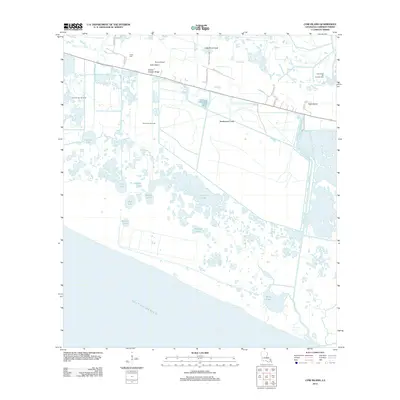
2012 Map of Cow Island
USGS Topo · Published 2012About this map
Grand Chenier Ridge stands as a defining topographic feature in this coastal Louisiana landscape, providing a narrow band of elevated ground amidst the sprawling marshes of Cameron Parish. This survey illustrates the delicate balance between the natural wetlands and the region's industrial footprint, showing multiple petroleum extraction sites like the Little Pecan Oil and Gas Field and Price Lake Gas Field. The settlement of Cow Island and the nearby Circle Cem mark the human presence along the ridge, while the vast southern portion of the map is dominated by a complex network of water bodies including Sturlese Lake, Tolan Lake, and Price Lake. These lakes are connected by man-made and natural waterways such as the Headquarters Canal and Joseph Harbor Bayou, eventually meeting the Gulf of Mexico along an intricate shoreline.
Find a feature on this map
30 named features on this map. Tap any name to fly to it.
Don’t see what you’re looking for? This feature index may not catch every label — zoom into the map to look around manually.
Map Details
Editions of this 2012 Cow Island Map
This is the sole edition of this map. No revisions or reprints were ever made.
Other maps of this area

1932 · Constance Bayou SW
USGS Topo · 1:31,680

1932 · Constance Bayou NW
USGS Topo · 1:31,680

1934 · Catfish Lake
USGS Topo · 1:24,000

1935 · Catfish Lake
USGS Topo · 1:31,680

1935 · Grand Chenier
USGS Topo · 1:31,680

1946 · Hog Bayou NE
USGS Topo · 1:31,680

1946 · Hog Bayou NW
USGS Topo · 1:31,680
1949 · Hog Bayou NW
USGS Topo · 1:31,680

1949 · Hog Bayou NE
USGS Topo · 1:31,680
1954 · Grand Lake East SW
USGS Topo · 1:31,680