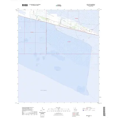
2024 Map of Cow Island
USGS Topo · Published 2024About this map
Grand Chenier Ridge and Hackberry Ridge form the primary high ground in this coastal landscape of Cameron Parish, where the land transitions from marshy wetlands to the open Gulf of Mexico. This 2024 survey details the intricate network of water management features, such as the Little Pecan Canal and Headquarters Canal, which are essential for navigating and draining this low-lying territory.
Find a feature on this map
32 named features on this map. Tap any name to fly to it.
Don’t see what you’re looking for? This feature index may not catch every label — zoom into the map to look around manually.
Map Details
Editions of this 2024 Cow Island Map
This is the sole edition of this map. No revisions or reprints were ever made.
Other maps of this area

1932 · Constance Bayou SW
USGS Topo · 1:31,680

1932 · Constance Bayou NW
USGS Topo · 1:31,680

1934 · Catfish Lake
USGS Topo · 1:24,000

1935 · Catfish Lake
USGS Topo · 1:31,680

1935 · Grand Chenier
USGS Topo · 1:31,680

1946 · Hog Bayou NE
USGS Topo · 1:31,680

1946 · Hog Bayou NW
USGS Topo · 1:31,680
1949 · Hog Bayou NW
USGS Topo · 1:31,680

1949 · Hog Bayou NE
USGS Topo · 1:31,680
1954 · Grand Lake East SW
USGS Topo · 1:31,680