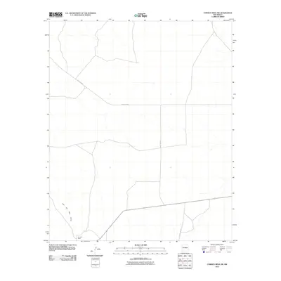
2010 Map of Cowboy Mesa NW
USGS Topo · Published 2010About this map
Reynolds Ranch serves as a primary point of human settlement within this high-desert landscape in Lincoln County. The area is defined by a network of drainage systems and intermittent watercourses, most notably the winding path of the Cola del Gallo Arroyo in the southwest. A framework of rural infrastructure connects these disparate points, with County Rd-B041 and County Rd-B019 providing the essential transit corridors across the mesa terrain. This 2010 survey illustrates the enduring patterns of ranching life and the sparse, purposeful placement of roads and homesteads in a region where water management and topography dictate the layout of the land.
Find a feature on this map
4 named features on this map. Tap any name to fly to it.
Don’t see what you’re looking for? This feature index may not catch every label — zoom into the map to look around manually.
Map Details
Editions of this 2010 Cowboy Mesa NW Map
This is the sole edition of this map. No revisions or reprints were ever made.
Other maps of this area

1954 · Fort Sumner
USGS Topo · 1:250,000

1958 · Fort Sumner
USGS Topo · 1:250,000

1980 · Corona
USGS Topo · 1:100,000

1981 · Cowboy Mesa NE
USGS Topo · 1:24,000

1981 · Gacho Hill SW
USGS Topo · 1:24,000

1981 · Camaleon Draw East
USGS Topo · 1:24,000

1981 · Cowboy Mesa SW
USGS Topo · 1:24,000
1981 · Cowboy Mesa
USGS Topo · 1:24,000

1981 · Gacho Hill SE
USGS Topo · 1:24,000
1981 · Cowboy Mesa NW
USGS Topo · 1:24,000