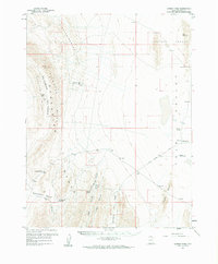
1959 Map of Cowboy Pass
USGS Topo · Published 1961About this map
Confusion Range dominance defines this high-desert basin in the late 1950s, where the dramatic peaks of Plympton Ridge and Chevron Ridge overlook the broad expanse of Tule Valley. The landscape is a study in western water management and travel, centered on vital points like Willow Spring and the Confusion Hills Res. Topographic detail reveals specialized features such as Big Horseshoe and Little Horseshoe, alongside the winding path of the Tule Spring Road as it skirts the Chalk Knolls.
Find a feature on this map
25 named features on this map. Tap any name to fly to it.
Don’t see what you’re looking for? This feature index may not catch every label — zoom into the map to look around manually.
Map Details
Editions of this 1959 Cowboy Pass Map
2 editions found
Other maps of this area

1908 · Fish Springs
USGS Topo · 1:250,000

1910 · Fish Springs
USGS Topo · 1:250,000

1953 · Delta
USGS Topo · 1:250,000

1958 · Delta
USGS Topo · 1:250,000

1959 · Cowboy Pass
USGS Topo · 1:62,500

1960 · Notch Peak
USGS Topo · 1:62,500

1960 · Granite Mountain
USGS Topo · 1:62,500

1960 · Conger Range
USGS Topo · 1:62,500

1960 · Gandy
USGS Topo · 1:62,500

1960 · Conger Mountain
USGS Topo · 1:62,500