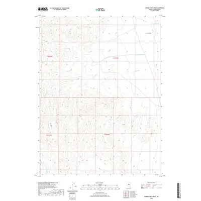
2018 Map of Cowboy Rest Creek
USGS Topo · Published 2018About this map
Grass Valley serves as a central feature in this section of Lander County, where the high-desert landscape is defined by the drainage patterns of seasonal creeks. This 2018 survey by the U.S. Geological Survey captures the rugged hydrography of the region, including the headwaters of Cowboy Rest Cr and Rosebush Cr. These watercourses carve through the interior, while Corral Canyon Cr and N Fork Skull Cr define the northern and southern reaches of the quadrangle.
Find a feature on this map
9 named features on this map. Tap any name to fly to it.
Don’t see what you’re looking for? This feature index may not catch every label — zoom into the map to look around manually.
Map Details
Editions of this 2018 Cowboy Rest Creek Map
This is the sole edition of this map. No revisions or reprints were ever made.
Other maps of this area

1926 · Roberts Mountains
USGS Topo · 1:250,000

1929 · Roberts Mountains
USGS Topo · 1:250,000

1955 · Millett
USGS Topo · 1:250,000

1956 · Mount Callaghan
USGS Topo · 1:62,500

1956 · Walti Hot Springs
USGS Topo · 1:62,500

1956 · Hall Creek
USGS Topo · 1:62,500

1956 · Ackerman Canyon
USGS Topo · 1:62,500

1959 · Millett
USGS Topo · 1:250,000

1979 · Simpson Park Mtns
USGS Topo · 1:100,000
1986 · Hall Creek North
USGS Topo · 1:24,000