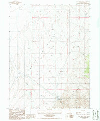
1986 Map of Hall Creek North
USGS Topo · Published 1986About this map
Carico Lake Valley occupies the heart of this Nevada landscape, framed by the ascending slopes of the Toyabe Range to the southeast. At the edge of the high desert basin, the Hall Creek Ranch serves as a lonely outpost of settlement, situated near the confluence of local drainages. The hydrology of the area is defined by the seasonal flow of Iowa Creek and Hall Creek, which descend from the surrounding peaks toward the valley floor. To the east, the terrain becomes increasingly complex with features like Dead Ox Canyon cutting through the mountains. This mid-1980s provisional study captures the sparse, ranch-oriented land use and high-elevation terrain of Lander County, including a vital Spring located high in the range, which supported both livestock and wildlife in this arid environment.
Find a feature on this map
10 named features on this map. Tap any name to fly to it.
Don’t see what you’re looking for? This feature index may not catch every label — zoom into the map to look around manually.
Map Details
Editions of this 1986 Hall Creek North Map
This is the sole edition of this map. No revisions or reprints were ever made.
Other maps of this area

1926 · Roberts Mountains
USGS Topo · 1:250,000

1929 · Roberts Mountains
USGS Topo · 1:250,000

1932 · Sonoma Range
USGS Topo · 1:250,000

1939 · Sonoma Range
USGS Topo · 1:250,000

1955 · Millett
USGS Topo · 1:250,000

1955 · Winnemucca
USGS Topo · 1:250,000

1956 · Hall Creek
USGS Topo · 1:62,500

1958 · Winnemucca
USGS Topo · 1:250,000

1959 · Millett
USGS Topo · 1:250,000

1961 · The Cedars
USGS Topo · 1:62,500