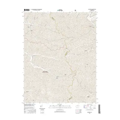
2016 Map of Cowcreek
USGS Topo · Published 2016About this map
Lerose and Turkey anchor this high-relief landscape in the heart of the Cumberland Plateau, where the boundary between Breathitt and Owsley counties zig-zags across the ridges. The terrain is defined by a dense network of hollows, including Halcomb Hollow and Wolfpen Hollow, which provide the narrow corridors for local roads like Rose Fork Rd and Houston Rd. This 2016 survey shows a pattern of settlement closely tied to the drainages, with small communities such as Arnett and Ricetown situated along the lower elevations. A portion of the Daniel Boone National Forest protects the southern reaches of the quadrangle, preserving the steep wooded slopes near Rice Knob and the headwaters of the Lucky Fork. The map provides a contemporary view of this rural Appalachian area, where traditional place names and family-named roads like Beach Turner Rd persist.
Find a feature on this map
43 named features on this map. Tap any name to fly to it.
Don’t see what you’re looking for? This feature index may not catch every label — zoom into the map to look around manually.
Map Details
Editions of this 2016 Cowcreek Map
This is the sole edition of this map. No revisions or reprints were ever made.
Other maps of this area

1889 · Salyersville
USGS Topo · 1:125,000

1891 · Manchester
USGS Topo · 1:125,000

1891 · Hazard
USGS Topo · 1:125,000

1891 · Salyersville
USGS Topo · 1:125,000

1892 · Beattyville
USGS Topo · 1:125,000

1899 · Salyersville
USGS Topo · 1:125,000

1913 · Buckhorn
USGS Topo · 1:62,500

1951 · Jackson
USGS Topo · 1:24,000

1952 · Tallega
USGS Topo · 1:24,000

1952 · Beattyville
USGS Topo · 1:24,000