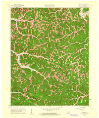
1961 Map of Cowcreek
USGS Topo · Published 1961About this map
Owsley and Breathitt counties meet in this 1961 survey, where the winding Middle Fork Kentucky River cuts through the northeastern corner. The landscape is defined by an intricate network of narrow creek valleys and named forks, including Cow Creek and Beech Fork, where small settlements and schoolhouses anchored rural life. Communities like Lerose and Spencer follow the Meadow Fork, while Ricetown sits at the confluence of the Left Fork and Right Fork in the west.
Find a feature on this map
45 named features on this map. Tap any name to fly to it.
Don’t see what you’re looking for? This feature index may not catch every label — zoom into the map to look around manually.
Map Details
Editions of this 1961 Cowcreek Map
This is the sole edition of this map. No revisions or reprints were ever made.
Other maps of this area

1889 · Salyersville
USGS Topo · 1:125,000

1891 · Manchester
USGS Topo · 1:125,000

1891 · Hazard
USGS Topo · 1:125,000

1891 · Salyersville
USGS Topo · 1:125,000

1892 · Beattyville
USGS Topo · 1:125,000

1899 · Salyersville
USGS Topo · 1:125,000

1913 · Buckhorn
USGS Topo · 1:62,500

1951 · Jackson
USGS Topo · 1:24,000

1952 · Tallega
USGS Topo · 1:24,000

1952 · Beattyville
USGS Topo · 1:24,000