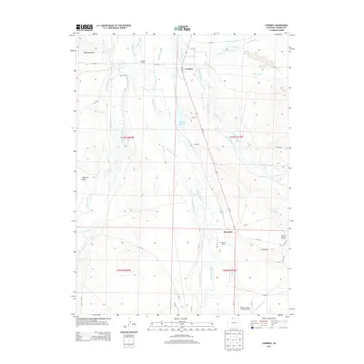
2013 Map of Cowdrey
USGS Topo · Published 2013About this map
The Michigan River and Canadian River converge in this high-altitude landscape dominated by extensive water management systems. The small community of Cowdrey sits at the center of an intricate network of irrigation projects, including the Pioneer Ditch, Cumberland Ditch, and the curiously named Give A Dam Jones Ditch. These waterways support family holdings such as Hanson Ranch and Carlstrom Ranch, illustrating the region's historical reliance on agricultural water rights. To the southeast, the North Mc Callum Oil Field indicates the transition toward energy extraction, while the presence of the Walden-Jackson County Airport provides a link to the broader county seat nearby. This survey preserves the exact footprint of early 21st-century ranching and resource development in Jackson County.
Find a feature on this map
58 named features on this map. Tap any name to fly to it.
Don’t see what you’re looking for? This feature index may not catch every label — zoom into the map to look around manually.
Map Details
Editions of this 2013 Cowdrey Map
This is the sole edition of this map. No revisions or reprints were ever made.
Other maps of this area
1950 · Northgate
USGS Topo · 1:24,000
1950 · Kings Canyon
USGS Topo · 1:24,000
1952 · Northgate
USGS Topo · 1:24,000
1952 · Kings Canyon
USGS Topo · 1:24,000

1954 · Craig
USGS Topo · 1:250,000
1955 · Independence Mountain
USGS Topo · 1:24,000
1955 · Lake John
USGS Topo · 1:24,000
1955 · Eagle Hill
USGS Topo · 1:24,000
1955 · Delaney Butte
USGS Topo · 1:24,000
1955 · Gould NW
USGS Topo · 1:24,000