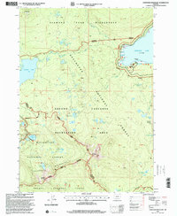
1997 Map of Cowhorn Mountain
USGS Topo · Published 2001About this map
Cowhorn Mountain stands as a central landmark in this high-elevation wilderness where the borders of the Willamette, Deschutes, and Umpqua National Forests converge. The geography is defined by a dense concentration of subalpine waters, including the sprawling Crescent Lake with its named coves like Tandy Bay and Tranquil Cove. This late 20th-century revision captures the intricate network of the Pacific Crest National Scenic Trail as it winds through the Oregon Cascades Recreation Area and the Diamond Peak Wilderness. The map reveals a landscape shaped by glacial and volcanic activity, from the heights of Sawtooth Mountain to the remote Bingham Lakes and Windy Lakes. It serves as a detailed record of backcountry access and natural boundaries, marking the division between Douglas and Klamath counties along the spine of the Calapooya Mountains.
Find a feature on this map
44 named features on this map. Tap any name to fly to it.
Don’t see what you’re looking for? This feature index may not catch every label — zoom into the map to look around manually.
Map Details
Editions of this 1997 Cowhorn Mountain Map
This is the sole edition of this map. No revisions or reprints were ever made.
Other maps of this area

1917 · Diamond Lake
USGS Topo · 1:125,000

1925 · Waldo Lake
USGS Topo · 1:125,000

1930 · Maiden Peak
USGS Topo · 1:125,000

1934 · Maiden Peak
USGS Topo · 1:125,000

1935 · Chemult
USGS Topo · 1:96,000

1941 · Chemult
USGS Topo · 1:125,000

1955 · Crescent
USGS Topo · 1:250,000

1956 · Waldo Lake
USGS Topo · 1:62,500

1956 · Summit Lake
USGS Topo · 1:62,500

1957 · Crescent
USGS Topo · 1:250,000