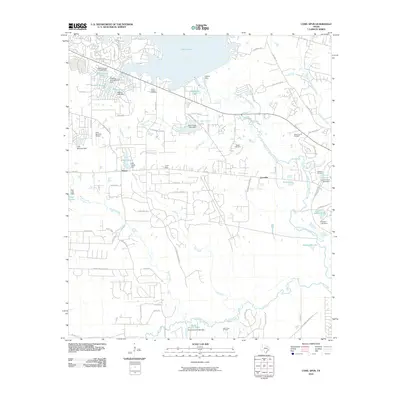
2010 Map of Cowl Spur
USGS Topo · Published 2010About this map
The West Fork San Jacinto River and its numerous tributaries, such as Egypt Creek and Fish Creek, define the topography of this Montgomery County landscape. In the north, the southern edge of Lake Conroe meets the Conroe Dam, while smaller water bodies like Artesian Lake and Scott Lake are scattered across the terrain. These lakes often reflect the region's mid-century water management, indicated by structures like the Lake Forest Falls Dam and Lake Bonanza Dam.
Find a feature on this map
81 named features on this map. Tap any name to fly to it.
Don’t see what you’re looking for? This feature index may not catch every label — zoom into the map to look around manually.
Map Details
Editions of this 2010 Cowl Spur Map
This is the sole edition of this map. No revisions or reprints were ever made.
Other maps of this area

1954 · Beaumont
USGS Topo · 1:250,000

1957 · Beaumont
USGS Topo · 1:250,000

1958 · Conroe
USGS Topo · 1:24,000

1958 · Cowl Spur
USGS Topo · 1:24,000

1958 · Lake Paula
USGS Topo · 1:24,000

1959 · Montgomery
USGS Topo · 1:24,000

1960 · Willis
USGS Topo · 1:24,000
1961 · Tamina
USGS Topo · 1:24,000

1962 · Keenan
USGS Topo · 1:24,000
1962 · Oklahoma
USGS Topo · 1:24,000