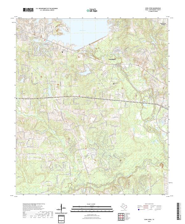
2022 Map of Cowl Spur
USGS Topo · Published 2022About this map
The W Fork San Jacinto River and its numerous tributaries, including Mound Creek and Fish Creek, define the rolling Montgomery County landscape depicted in this modern survey. The southern tip of Lake Conroe dominates the northern edge, surrounded by residential developments like Lakeview Village and the golf courses of Panorama Village. The historic community of Honea sits central to the map, marking a transition between the suburban expansion of Conroe and the timbered drainage basins of Lake Creek. Family-named landmarks such as Pevehouse Lake and the Elizabeth Ridge offer tangible connections for genealogists, while several small burying grounds, including Copeland Chapel Cem and Sapp Cem, remain preserved amidst the growing suburban network of roads like FM 2854 and Woodforest Blvd.
Find a feature on this map
68 named features on this map. Tap any name to fly to it.
Don’t see what you’re looking for? This feature index may not catch every label — zoom into the map to look around manually.
Map Details
Editions of this 2022 Cowl Spur Map
This is the sole edition of this map. No revisions or reprints were ever made.
Other maps of this area

1954 · Beaumont
USGS Topo · 1:250,000

1957 · Beaumont
USGS Topo · 1:250,000

1958 · Conroe
USGS Topo · 1:24,000

1958 · Cowl Spur
USGS Topo · 1:24,000

1958 · Lake Paula
USGS Topo · 1:24,000

1959 · Montgomery
USGS Topo · 1:24,000

1960 · Willis
USGS Topo · 1:24,000
1961 · Tamina
USGS Topo · 1:24,000

1962 · Keenan
USGS Topo · 1:24,000
1962 · Oklahoma
USGS Topo · 1:24,000